Situated at the point where the Duoro River meets the Atlantic Ocean in Northern Portugal, Porto has been a mercantile city since its earliest days as a Roman outpost. As one of Europe’s oldest cities, it boasts a wealth of cultural and historical attractions too, including a recently revamped medieval district bordering the scenic waterfront. Beautiful examples of baroque architecture are scattered around the old part of town as well. Walking tours offers a great way to explore the city, as most of the major tourist attractions in Porto are located close to each other. Porto’s most celebrated contribution to Portuguese culture is port wine, the nation’s top export. Visits to Porto typically include trips to the port wine caves located just across the river at Vila Nova de Gaia.
See Also


READ MORE
See Also
Best Hotels in Lisbon
Where to Stay in Portugal
10 Serralves Museum

Porto has long been a haven for great artists and architects looking for work, but it wasn’t until the 20th century that the city spawned its own unique architectural style. The so-called Porto School of the 1950s inspired a generation of architects, including Álvaro Siza Vieira, the designer of the Contemporary Art Museum at the Serralves cultural institution. The minimalist building and the surrounding park attracts as many visitors as the changing international exhibits showcased within its white walls. Outdoor art installations dot the landscaped park and gardens.
9 Sao Francisco Church
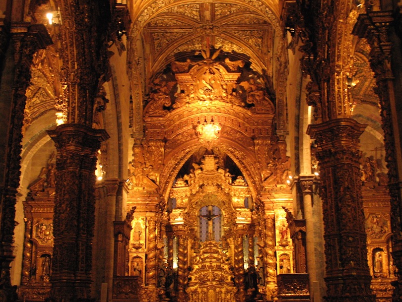
The 14th-century Igreja de Sao Francisco is the most prominent example of Gothic architecture in Porto. Originally part of the St. Francis Convent built in the 13th century, the church is the only structure that survived a fire in 1842. A steep climb from the riverside leads visitors to the massive stone façade, which is ornamented by a large rosette window. The interior of the church was given a baroque makeover in the 18th century when almost all of the aisles, pillars and chapels were covered with lavishly ornamented gilded carvings featuring cherubs, flowers and animals.
8 Casa da Musica

When it comes to contemporary architecture, the Casa da Musica is a standout attraction. Designed by Dutch architect Rem Koolhaas, the new home for the National Orchestra of Porto opened in 2005 to great acclaim. With its innovative design inside and out, the structure has already been adopted by the city as an iconic landmark. Concerts are held in the hall nearly every night of the year, with shows ranging from rock bands and solo artists to full symphony orchestras. Guided tours of the facility are offered daily, and special packages include backstage passes and free samples of port wine.
7 Porto Cathedral

The parents of Portugal’s first king, Dom Afonso Henriques, are credited with the construction of the 12th-century Sé do Porto, but the cathedral has actually been rebuilt twice over the centuries. Offering a history of changing architectural styles, the reconstructions are now part of this famous structure’s appeal. From its Gothic rose window and cloister to the baroque chapel with its ornate silver altarpiece, the cathedral is a must-see attraction for anyone interested in history, art and architecture. A staircase ornamented with painted ceramic tile work leads to a second level where narrow windows offer impressive views.
6 Dom Luis Bridge

The Ponte de Dom Luis I is the most famous of the several bridges that span the Duoro River. Built in 1886, it was designed by Téophile Seyrig, an engineer who worked with Gustave Eiffel. The massive iron bridge has both an upper and lower deck, both of which carried road traffic until 2003 when the top span was converted to accommodate a light rail system. A pedestrian walkway on the upper deck offers spectacular views as well as a direct walking route to the port wine lodges across the river in Vila Nova de Gaia.
5 Palacio da Bolsa

Located adjacent to the Sao Francisco Church, the Palácio da Bolsa is a massive Neoclassic structure constructed on the site of the former St. Francis Convent. Funded by the Porto’s commercial association, the palace was built as a stock exchange and was designed to impress Europe’s economic leaders. Several architects worked on the building during its nearly 70-year construction period. Designed in a Moorish style by Gustavo Adolfo Gonçalves e Sousa, the Arab Room is a highlight for any tour of the palace. One of the most popular tourist attractions in Porto, the striking space is still used as a reception hall for visiting dignitaries today.
4 Livraria Lello
Along with an inventory of more than 60,000 books, an exuberant mix of Art Deco and Gothic Revival architectural styles makes the Livraria Lello one of the most famous bookstores in Europe. Rumored to have provided inspiration for author J.K. Rowling, who worked as an English teacher in Porto when writing the Harry Potter books, the bookstore is now visited by fans of the series from all over the world. In addition to books covering every nook and cranny, the century-old shop features a double helix staircase, a stained-glass skylight and a small café on the second floor.
3 Clerigos Tower

Baroque exuberance is on full display at the 18th-century tower of the Igreja dos Clerigos, or Church of the Clergy. Designed by Italian painter and architect Nicolau Nasoni in 1754, the Torre dos Clerigos is a Porto landmark and a can’t-miss attraction. The ornate tower rises some 250 feet (76 meters) high, making it one of the tallest structures in Northern Portugal. Visitors who undertake the 255-step climb to the tower’s belfry are rewarded with panoramic views of the city and of the Duoro river estuary. Audio tours are available for an extra fee.
2 Ribeira

Many travelers to Porto begin their visit in the Ribeira, the medieval historic district located near the Duoro River. At the Praça da Ribeira, the narrow cobblestone streets spill out onto a scenic plaza where locals and tourists relax in the sun and enjoy views of the estuary. With its many seafood restaurants and taverns, the Ribeira Pier is a popular gathering spot too. It’s also a departure point for cruises on the river and for boat rides to the port wine cellars in Vila Nova de Gaia. For those traveling by foot or car, the Cais da Ribeira offers easy access to Dom Luis Bridge as well.
1 Vila Nova de Gaia

While technically its own city, Vila Nova de Gaia is situated just across the Douro from Porto and is woven into the city’s fabric both by a series of bridges as well as its shared history of port-wine making. The most popular tourist attraction in Gaia are the Port Wine Cellars, warehouses where the famous Port wine is stored. The Cellars are placed in Ribeira de Gaia, an area of the city located in the bank of River Douro opposite Porto. Ribeira de Gaia has also some excellent restaurants, particularly in Cais de Gaia. Even if you are not in visiting the cellars, you should visit Ribeira the Gaia in order to get some amazing views of Porto.
Related Travel Lists
10 Best Places to Visit in Portugal
6 Most Popular Attractions in Sintra
Map of Tourist Attractions In Porto

Leave a Reply
Your email address will not be published. Required fields are marked *
Constructed : Late 12th century – 1191
Religion: Buddhism
Style : Bayon
King : Jayavarman VII ★ 1181 – 1218 ★
Location : On the large circuit, in the North of Angkor Thom,
approximately two kilometres after the Northern Gate.
Comment : Beautiful to be cried! Preah Khan, “the crowned sword”, it is the most beautiful monument of whole Angkor! Built by Jayavarman VII little after Ta Phrom, but in the honor of his father, this temple is of an incomparable beauty. Unfortunately of broad part of this monument are reduced to heaps of stones which piled up during centuries and under the force of the vegetation and the bad weather.
Preah Khan, city of the Victory would have been built on the same spot where Jayavarman VII gained the victory over Chams, provisional royal city when the Royal Palace of Angkor Thom was downtown repair and especially monastic where unrolled many traditional and religious festivals.
 It was in fact a real city of 56 hectares. In spite of the vandalism and the plunder there’re still some magnificent sculptures. The city sheltered 10.000 persons, 1000 dancers and one Sanscrit’s school. Originally it was a convent Buddhist whose Buddha’s representations were destroyed by Brahmanes (Indian priests) and replaced by representations Hindus, (A single Bouddha representation stayed). To arrive in the center of the temple, a row of galleries and doors which become more and more low has measure that one approaches the centre (to show his respect). In the center, a stone, big Stuppa Bouddhiste which was brought in the XVth century. There’re small holes in all the walls in the center of the building. Originally, in every hole was some gold and diamonds, one says that all this was taken and resold by the Red Khmers. Magnificent sculptures of the gods barattant the sea of milk, as well as Vishnu and Lakshmi (his wife), and the place of 3 Lingams (sex of the Gods), circle on the base for Shiva, square for Brahma and octagonal for Vishnu. One finds as in Ta Phrom, a luxuriant vegetation which resumed its rights.
READ MORE
Religion: Buddhism
Style : Bayon
King : Jayavarman VII ★ 1181 – 1218 ★
Location : On the large circuit, in the North of Angkor Thom,
approximately two kilometres after the Northern Gate.
Comment : Beautiful to be cried! Preah Khan, “the crowned sword”, it is the most beautiful monument of whole Angkor! Built by Jayavarman VII little after Ta Phrom, but in the honor of his father, this temple is of an incomparable beauty. Unfortunately of broad part of this monument are reduced to heaps of stones which piled up during centuries and under the force of the vegetation and the bad weather.
Preah Khan, city of the Victory would have been built on the same spot where Jayavarman VII gained the victory over Chams, provisional royal city when the Royal Palace of Angkor Thom was downtown repair and especially monastic where unrolled many traditional and religious festivals.

Constructed : Early 12th century
Religion: Hindu
Style : Angkor Wat
King : Suryavarman II ★ 1113 – 1150 ★
Location : A group of 5 sanctuaries in the Angkor Thom group.
Comment : Preah Pithu Group is the compound ruins where the open space before the court is located septentrional. It consists of the plural buildings, but is not to be made under one plan, it seems. You call septentrional of the open space before the court, there is a position where it is easy to visit in plain existence, it seems that is not either the person whom it visits excessively in spite.
Temple T and U state are not good, but as for temple X restoration has ended. The relief of the stylobate section of temple V state is beautiful well. It is the good place known to few people ruins which can enjoy to the whole quiet atmosphere. Septentrional of the ruins there is a pond and a Buddhism temple where the flower of the lotus blooms.

READ MORE
Religion: Hindu
Style : Angkor Wat
King : Suryavarman II ★ 1113 – 1150 ★
Location : A group of 5 sanctuaries in the Angkor Thom group.
Comment : Preah Pithu Group is the compound ruins where the open space before the court is located septentrional. It consists of the plural buildings, but is not to be made under one plan, it seems. You call septentrional of the open space before the court, there is a position where it is easy to visit in plain existence, it seems that is not either the person whom it visits excessively in spite.
Temple T and U state are not good, but as for temple X restoration has ended. The relief of the stylobate section of temple V state is beautiful well. It is the good place known to few people ruins which can enjoy to the whole quiet atmosphere. Septentrional of the ruins there is a pond and a Buddhism temple where the flower of the lotus blooms.

Constructed : Early 7th century – 616
Religion: Hindu
Style : Sambor Prei Kuk
King : Isanavarman I ★ 611 – 635 ★
Location : Located in Sam Bor village, 37km from
Kampong Thom on National Highway No.64.
Sambor Prei Kuk is a former capital and was previously named Isan Borak and once a capital of Chenla between 7th and 8th century in pre-Angkorean period. A religious center dedicated to Shiva, Sambor Prei Kuk temple is made of solid brick and some laterite stone and is decorated with sculptures. The artistic front of Sar Sor Pich (Diamond pillar) and the door frames are made of sandstone.
 This temple was abandoned in 1971 and restored in 1980. A further 140 sites has been found in the forest nearby and two other known temples have yet to be discovered. They are not big but unique in it’s style of lintel (Sambor Prei Kuk style), relief on the wall of the temples (flying palace) and octagonal plan.
When Sambor Prei Kuk is enjoyed, the male be completed it does that knowledge of the minimum is obtained history of thing and Sambor Prei Kuk who look at the principal ruins first with Angkor, concerning construction and the fine arts.
Phosphorus Telecom of the sandstone where the part where it should observe carved the wall surface of the brick of the hall and the “aerial palace” and, this and is provided on the door of the hall (the lintel) with, in each case are type rare beauty. Also beauty of the light ray which is inserted inside the hall in octagon is worthy of to attention.
READ MORE
Religion: Hindu
Style : Sambor Prei Kuk
King : Isanavarman I ★ 611 – 635 ★
Location : Located in Sam Bor village, 37km from
Kampong Thom on National Highway No.64.
Sambor Prei Kuk is a former capital and was previously named Isan Borak and once a capital of Chenla between 7th and 8th century in pre-Angkorean period. A religious center dedicated to Shiva, Sambor Prei Kuk temple is made of solid brick and some laterite stone and is decorated with sculptures. The artistic front of Sar Sor Pich (Diamond pillar) and the door frames are made of sandstone.
 This temple was abandoned in 1971 and restored in 1980. A further 140 sites has been found in the forest nearby and two other known temples have yet to be discovered. They are not big but unique in it’s style of lintel (Sambor Prei Kuk style), relief on the wall of the temples (flying palace) and octagonal plan.
When Sambor Prei Kuk is enjoyed, the male be completed it does that knowledge of the minimum is obtained history of thing and Sambor Prei Kuk who look at the principal ruins first with Angkor, concerning construction and the fine arts.
Phosphorus Telecom of the sandstone where the part where it should observe carved the wall surface of the brick of the hall and the “aerial palace” and, this and is provided on the door of the hall (the lintel) with, in each case are type rare beauty. Also beauty of the light ray which is inserted inside the hall in octagon is worthy of to attention.
Constructed : Early 10th century.
Religion : Hindu (god Shiva)
Style : Banteay Srei
King : Suryavarman I & II ★ 1002 -1050 ★
Location : In Svay Chrum Village, Kan Tout Commune, Choam Khsant District of Preah Vihear province of northern Cambodia. The temple is 140 km from Angkor Wat and 320 km from Phnom Penh.
Comment : Construction of the first temple on the site began in the early 9th century; both then and in the following centuries it was dedicated to the Hindu god Shiva in his manifestations as the mountain gods Sikharesvara and Bhadresvara.

The earliest surviving parts of the temple, however, date from the Koh Ker period in the early 10th century, when the empire’s capital was at the city of that name. Today, elements of the Banteay Srei style of the late 10th century can be seen, but most of the temple was constructed during the reigns of the Khmer kings Suryavarman I (1002 -1050) and Suryavarman II (1113 -1150). An inscription found at the temple provides a detailed account of Suryavarman II studying sacred rituals, celebrating religious festivals and making gifts, including white parasols, golden bowls and elephants, to his spiritual advisor, the aged Brahmin Divakarapandita.


READ MORE
Religion : Hindu (god Shiva)
Style : Banteay Srei
King : Suryavarman I & II ★ 1002 -1050 ★
Location : In Svay Chrum Village, Kan Tout Commune, Choam Khsant District of Preah Vihear province of northern Cambodia. The temple is 140 km from Angkor Wat and 320 km from Phnom Penh.
Comment : Construction of the first temple on the site began in the early 9th century; both then and in the following centuries it was dedicated to the Hindu god Shiva in his manifestations as the mountain gods Sikharesvara and Bhadresvara.

The earliest surviving parts of the temple, however, date from the Koh Ker period in the early 10th century, when the empire’s capital was at the city of that name. Today, elements of the Banteay Srei style of the late 10th century can be seen, but most of the temple was constructed during the reigns of the Khmer kings Suryavarman I (1002 -1050) and Suryavarman II (1113 -1150). An inscription found at the temple provides a detailed account of Suryavarman II studying sacred rituals, celebrating religious festivals and making gifts, including white parasols, golden bowls and elephants, to his spiritual advisor, the aged Brahmin Divakarapandita.

The Brahmin himself took an interest in the temple, according to the inscription, donating to it a golden statue of a dancing Shiva known as “Nataraja”. In the wake of the decline of Hinduism in the region the site was converted to use by Buddhists.


Style : Bayon
King : Unknown
Location : Small circuit, between Ta Keo and Thommanon.
Comment : Spean Thma, the bridge of stone. It would have been rebuilt several times and is hardly of interest the more so as it is possible to see many bridges in better states on the road from Siem reap in Phnom Penh. Spean Thma will be noticed nevertheless that the bridge is currently to a hundred meters from the river what shows at which point the water court moved with time.
Constructed : Late 10th century – 967
Religion: Hindu
Style : Banteay Srei
King : Rajendravarman II ★ 944 – 968 ★ & Jayavarman V ★ 968 – 1001 ★
Location : At 37 km in North East of Siem Reap, and about 20 km from the large circuit, the road of Banteay Srei is very practicable and now indicated well.
Comment : Jewel of Khmer art, this temple with restricted dimensions is well outside the whole of Angkor, in a zone still difficult of access a short time ago, which explains its relatively late discovery and its restoration which intervened only after the complete release in 1924.
It emanates from this small temple a very special softness, a kind of undoubtedly calms mainly with the colour of the stones used for its construction, a pink liking which slightly changes colour with the sun. The many sculptures, their smoothness and their excellent state of conservation contribute to the charm of this unit.
 The term of “Banteay Srei” can be translated by “fortress of the women” but its real significance differs according to various interpretations. Some say that this temple was built by women, of other, that it was reserved to the women, or that many women there were found, but most probable in our eyes is that according to which the temple would have been built in homage to the women.
The visit of Banteay Srei is to be envisaged over at least a half-day, visits that one will be able to combine with that of Banteay Samre and, on the return at the end of the afternoon with the splendid sunset visible from the top of Pre Rup.
READ MORE
Religion: Hindu
Style : Banteay Srei
King : Rajendravarman II ★ 944 – 968 ★ & Jayavarman V ★ 968 – 1001 ★
Location : At 37 km in North East of Siem Reap, and about 20 km from the large circuit, the road of Banteay Srei is very practicable and now indicated well.
Comment : Jewel of Khmer art, this temple with restricted dimensions is well outside the whole of Angkor, in a zone still difficult of access a short time ago, which explains its relatively late discovery and its restoration which intervened only after the complete release in 1924.
It emanates from this small temple a very special softness, a kind of undoubtedly calms mainly with the colour of the stones used for its construction, a pink liking which slightly changes colour with the sun. The many sculptures, their smoothness and their excellent state of conservation contribute to the charm of this unit.

The visit of Banteay Srei is to be envisaged over at least a half-day, visits that one will be able to combine with that of Banteay Samre and, on the return at the end of the afternoon with the splendid sunset visible from the top of Pre Rup.
Constructed : Late 12th/Early 13th century – 1186
Religion: Buddhism
Style : Bayon
King : Jayavarman VII ★ 1181 – 1218 ★
Location : On the large circuit, just beside Banteay Kdei. East of Angkor Thom.
Comment : Ta Prohm temple is certainly one of most impressive, if not most impressive of all the temples of the site of Angkor . It was to be in its time a gigantic monastic city and when you enter by the Est gate, while moving through this splendid forest towards the temple itself, it is necessary to imagine that you cross an active city of many people where houses, made light materials entirely disappeared with Time. Inscriptions indicate that 80.000 people worked at the service of this monastery and inter alias the monks used 5 tons of gold plate! Ta Phrom forms part of the last generation of Angkorian temples, on only one level, surrounded by many galleries. You will be immediately impressed by the number, the size and the quality of the still intact galleries.
 The others are only fall and heap of stones. The French School of Extreme Orient, which is at the base of many work of restoration of Angkor, would have voluntarily left this temple in this state of decay, where nature continues its work destroying in order to give to the visitor this very special impression to discover a wild place. The EFEO is as justified by saying as there exists on the site of Angkor many other examples of this kind of architecture, like Banteay Srey or the very close Banteay Kdei, but also releases itself from an enormous task, it is enough for persuaded to look at the numbers of stones scattered on the ground. In addition, the roots which surround the walls and invade certain galleries are a true treat for the eyes and the photographers! Set up five years after the arrival on the throne of Jayavarman VII, Ta Phrom is dedicated to his mother, and is formed part of the temples dedicated to the divinized parents. It will build later Preah Khan in the honor of his father. To be visited absolutely.
Ta Prohm is a Buddhism temple ruins like one city that inside the immense site which east west 1000 meter north and south 600 meters. There is a mark of the ring moat which surrounds the third lap wall on left and right. The next second lap wall does with the laterite. Inside having become the corridor, the roof of the sandstone is riding. As for the banyan tree with the very much high trees and shrubs, there is no branch excluding the part of the canopy. The key also voice of the bird which calls sharply has emphasized strange atmosphere.
READ MORE
Religion: Buddhism
Style : Bayon
King : Jayavarman VII ★ 1181 – 1218 ★
Location : On the large circuit, just beside Banteay Kdei. East of Angkor Thom.
Comment : Ta Prohm temple is certainly one of most impressive, if not most impressive of all the temples of the site of Angkor . It was to be in its time a gigantic monastic city and when you enter by the Est gate, while moving through this splendid forest towards the temple itself, it is necessary to imagine that you cross an active city of many people where houses, made light materials entirely disappeared with Time. Inscriptions indicate that 80.000 people worked at the service of this monastery and inter alias the monks used 5 tons of gold plate! Ta Phrom forms part of the last generation of Angkorian temples, on only one level, surrounded by many galleries. You will be immediately impressed by the number, the size and the quality of the still intact galleries.
 The others are only fall and heap of stones. The French School of Extreme Orient, which is at the base of many work of restoration of Angkor, would have voluntarily left this temple in this state of decay, where nature continues its work destroying in order to give to the visitor this very special impression to discover a wild place. The EFEO is as justified by saying as there exists on the site of Angkor many other examples of this kind of architecture, like Banteay Srey or the very close Banteay Kdei, but also releases itself from an enormous task, it is enough for persuaded to look at the numbers of stones scattered on the ground. In addition, the roots which surround the walls and invade certain galleries are a true treat for the eyes and the photographers! Set up five years after the arrival on the throne of Jayavarman VII, Ta Phrom is dedicated to his mother, and is formed part of the temples dedicated to the divinized parents. It will build later Preah Khan in the honor of his father. To be visited absolutely.
Ta Prohm is a Buddhism temple ruins like one city that inside the immense site which east west 1000 meter north and south 600 meters. There is a mark of the ring moat which surrounds the third lap wall on left and right. The next second lap wall does with the laterite. Inside having become the corridor, the roof of the sandstone is riding. As for the banyan tree with the very much high trees and shrubs, there is no branch excluding the part of the canopy. The key also voice of the bird which calls sharply has emphasized strange atmosphere.
Angkor Thom is undeniably an expression of the highest genius. It is, in three dimensions and on a scale worthy of an entire nation, the materialization of Buddhist cosmology, representing ideas that only great painters would dare to portray.
BACKGROUND
Angkor Thom, the last capital of the Khmer Empire, was a fortified cit enclosing residences of priest, officials of the palace and military, as well as buildings for administering the kingdom.

These structures were built of wood and have perished but the remaining stone monuments testify that Angkor Thom was indeed a "Great City" as its name implies. Temples inside the walls of the city described in this article are Bayon, Phimeanakas, Baphuon, Terrace of the Elephants, Terrace of the Leper King, Prah Palilay, Tep Pranam and Prasat Suor Prat.
 The Royal Palace situated within the city of Angkor Thom is of an earlier date and belonged to kings of the tenth and first half of the tenth and first half of the eleventh centuries. Although the foundations and an enclosing wall around the palace with entry towers have been identified, little evidence remains of the layout of the buildings inside the enclosure. This absence of archaeological evidence of the royal buildings suggests that they were constructed of wood and have perished.
The French ascertained a general plan of the Royal Palace (see map opposite). It included the temple-mountain of Phimeanakas and surrounding pools together with residences and buildings for administering the capital, which were probably at the back of the enclosure. Jayavarman VII reconstructed the original site of the Royal Palace Palace to erect the city of Angkor Thom, which was centered on the temple of Bayon and surrounded by a wall.
Zhou Daguan the Chinese emissary, who provided the only first-hand account o f the Khmer, described the splendor of Angkor Thom.
At the center of the Kingdom rises a Golden tower Bayon flanked by more than twenty lesser towers and several hundred stone chambers. On the eastern side is a golden bridge guarded by two lions of gold, one on each side, with eight golden Buddhas spaced along the stone chambers. North of the Golden Tower of Bronze [Baphuon], higher even than the Golden tower. a truly astonishing spectacle. With more than ten chambers at its base. A quarter of a mile further north is the residence of the King rising above his private apartments is another tower of gold, These are the monuments which have caused merchants from overseas to speak so often of "Cambodia the rich and noble "
Symbolically, Angkor Thom is a microcosm of the universe, divided into four parts by the main axes. The temple of the Bayon is situated at the exact center of the axes and stands as the symbolical link between heaven and earth. The wall enclosing the city of Angkor Thom represents the stonewall around the universe and the mountain ranges around Meru. The surrounding moat (now dry) symbolizes the cosmic ocean.

LAYOUT
The city of Angkor Thom consists of a square, each side of which is about three kilometers (1.9 miles) long a laterite wall 8 meters (26 feet) in height around the city encloses an are of 145.8 hectares (360 acres). A moat with a width of 100meters (328 feet) surrounds the outer wall. An entry tower and along causeway bisect each side of the wall except on the east where are two entrances. The additional one, called the "Gate of Victory "is aligned with the causeway leading to the Terraces of the Elephants and the Leper King. A small temple known as "Prasat Chrung' stands at each corner of the wall around the city of Angkor Thom.
An earth embankment 25 meters (82 feet) wide supports the inner side of the wall and serves as a road around the city.
CAUSEWAY WITH STONE FIGURES
A long causeway leading to each entry tower is flanked by a row of 54 stone figures on each side – demons on the right and gods on the left-to make a total of 108 mythical beings guarding the city of Angkor Thom. The demons have a grimacing expression and wear a military headdress whereas the gods look serene with their almond-shaped eyes and wear a conical headdress. (Some of the heads on these figures are copies; the original ones have been removed and are at the Angkor Conservancy in Siem Reap).
A serpent spreads its nine heads in the shape of a fan at the beginning of the causeway. Its body extends the length of the causeway and is held by the gods and demons forming a serpent-like railing. It may symbolize the rainbow uniting the worlds of man and the gods. This representation is reinforced by the presence of Indra.
A small sandstone temple dedicated to the bodhisattva Avalokitesvara occupies each corner of the wall enclosing the city of Angkor Thom. An inscription at the temple names Jayavarman VII as the builder and gives the charter of the foundation of the wall and moat of the city. Each temple is in the shape of a cross opens to the east with a porch on each side, and is crowned with a lotus-shaped top. Abase with two tiers supports the temple. Female figures in niches and false windows typical of the period decorate the exterior. The upper half of the window is sealed with laterite blocks in emulation of an awning; the lower half contains balusters.
ENTRY TOWERS
 Through here all comers to the city had to pass, and in honor of this function it has been built in a style grandiose and elegant, forming a whole, incomparable in its strength and expression.
The five entry towers are among the most photographed of all the ancient Cambodian ruins. Each sandstone tower rises 23 meters (75 feet) to the sky and is crowned with four heads, one facing each cardinal direction. The faces may represent the rulers of the four cardinal points at the summit of mount Meru.
The lower half of each gate is modeled like an elephant with three heads. Their trunks, which serve as pillars, are plucking lotus flowers. The Hindu god Indra sits at the center of the elephant with an Apsara on each side. He holds a thunderbolt in his lower left hand.
Looking through the tower one can see a corbel arch, a hallmark of Khmer architecture. Inside, wooden crossbeams are visible and a sentry box stands on each side.
READ MORE
BACKGROUND
Angkor Thom, the last capital of the Khmer Empire, was a fortified cit enclosing residences of priest, officials of the palace and military, as well as buildings for administering the kingdom.

These structures were built of wood and have perished but the remaining stone monuments testify that Angkor Thom was indeed a "Great City" as its name implies. Temples inside the walls of the city described in this article are Bayon, Phimeanakas, Baphuon, Terrace of the Elephants, Terrace of the Leper King, Prah Palilay, Tep Pranam and Prasat Suor Prat.
 The Royal Palace situated within the city of Angkor Thom is of an earlier date and belonged to kings of the tenth and first half of the tenth and first half of the eleventh centuries. Although the foundations and an enclosing wall around the palace with entry towers have been identified, little evidence remains of the layout of the buildings inside the enclosure. This absence of archaeological evidence of the royal buildings suggests that they were constructed of wood and have perished.
The French ascertained a general plan of the Royal Palace (see map opposite). It included the temple-mountain of Phimeanakas and surrounding pools together with residences and buildings for administering the capital, which were probably at the back of the enclosure. Jayavarman VII reconstructed the original site of the Royal Palace Palace to erect the city of Angkor Thom, which was centered on the temple of Bayon and surrounded by a wall.
Zhou Daguan the Chinese emissary, who provided the only first-hand account o f the Khmer, described the splendor of Angkor Thom.
At the center of the Kingdom rises a Golden tower Bayon flanked by more than twenty lesser towers and several hundred stone chambers. On the eastern side is a golden bridge guarded by two lions of gold, one on each side, with eight golden Buddhas spaced along the stone chambers. North of the Golden Tower of Bronze [Baphuon], higher even than the Golden tower. a truly astonishing spectacle. With more than ten chambers at its base. A quarter of a mile further north is the residence of the King rising above his private apartments is another tower of gold, These are the monuments which have caused merchants from overseas to speak so often of "Cambodia the rich and noble "
Symbolically, Angkor Thom is a microcosm of the universe, divided into four parts by the main axes. The temple of the Bayon is situated at the exact center of the axes and stands as the symbolical link between heaven and earth. The wall enclosing the city of Angkor Thom represents the stonewall around the universe and the mountain ranges around Meru. The surrounding moat (now dry) symbolizes the cosmic ocean.

LAYOUT
The city of Angkor Thom consists of a square, each side of which is about three kilometers (1.9 miles) long a laterite wall 8 meters (26 feet) in height around the city encloses an are of 145.8 hectares (360 acres). A moat with a width of 100meters (328 feet) surrounds the outer wall. An entry tower and along causeway bisect each side of the wall except on the east where are two entrances. The additional one, called the "Gate of Victory "is aligned with the causeway leading to the Terraces of the Elephants and the Leper King. A small temple known as "Prasat Chrung' stands at each corner of the wall around the city of Angkor Thom.
An earth embankment 25 meters (82 feet) wide supports the inner side of the wall and serves as a road around the city.
CAUSEWAY WITH STONE FIGURES
A long causeway leading to each entry tower is flanked by a row of 54 stone figures on each side – demons on the right and gods on the left-to make a total of 108 mythical beings guarding the city of Angkor Thom. The demons have a grimacing expression and wear a military headdress whereas the gods look serene with their almond-shaped eyes and wear a conical headdress. (Some of the heads on these figures are copies; the original ones have been removed and are at the Angkor Conservancy in Siem Reap).
A serpent spreads its nine heads in the shape of a fan at the beginning of the causeway. Its body extends the length of the causeway and is held by the gods and demons forming a serpent-like railing. It may symbolize the rainbow uniting the worlds of man and the gods. This representation is reinforced by the presence of Indra.
A small sandstone temple dedicated to the bodhisattva Avalokitesvara occupies each corner of the wall enclosing the city of Angkor Thom. An inscription at the temple names Jayavarman VII as the builder and gives the charter of the foundation of the wall and moat of the city. Each temple is in the shape of a cross opens to the east with a porch on each side, and is crowned with a lotus-shaped top. Abase with two tiers supports the temple. Female figures in niches and false windows typical of the period decorate the exterior. The upper half of the window is sealed with laterite blocks in emulation of an awning; the lower half contains balusters.
ENTRY TOWERS
 Through here all comers to the city had to pass, and in honor of this function it has been built in a style grandiose and elegant, forming a whole, incomparable in its strength and expression.
The five entry towers are among the most photographed of all the ancient Cambodian ruins. Each sandstone tower rises 23 meters (75 feet) to the sky and is crowned with four heads, one facing each cardinal direction. The faces may represent the rulers of the four cardinal points at the summit of mount Meru.
The lower half of each gate is modeled like an elephant with three heads. Their trunks, which serve as pillars, are plucking lotus flowers. The Hindu god Indra sits at the center of the elephant with an Apsara on each side. He holds a thunderbolt in his lower left hand.
Looking through the tower one can see a corbel arch, a hallmark of Khmer architecture. Inside, wooden crossbeams are visible and a sentry box stands on each side.
ANGKOR WAT was listed in World Wonder List
Angkor Wat, in its beauty and state of preservation, is unrivaled. Its mightiness and magnificence bespeak a pomp and a luxury surpassing that of a Pharaoh or a Shah Jahan, an impressiveness greater than that of the Pyramids, an artistic distinctiveness as fine as that of the Taj Mahal. Angkor Wat is located about six kilometers (four miles) north of Siem Reap, south of Angkor Thom. Entry and exit to Angkor Wat can only be access from its west gate.
Angkor Wat was built in the first half of the 12th century (113-5BC). Estimated construction time of the temple is 30 years by King Suryavarman II, dedicated to Vishnu (Hindu), replica of Angkor Thom style of art.

BACKGROUND
Angkor Wat, the largest monument of the Angkor group and the best preserved, is an architectural masterpiece. Its perfection in composition, balance, proportions, relief's and sculpture make it one of the finest monuments in the world.
Wat is the Khmer name for temple (the French spelling is "vat "), which was probably added to "Angkor "when it became a Theravada Buddhist monument, most likely in the sixteenth century. After 1432 when the capital moved to Phnom Penh, Angkor Wat was cared for by Buddhist monks.
It is generally accepted that Angkor Wat was a funerary temple for King Suryavarman II and oriented to the west to conform to the symbolism between the setting sun and death. The bas-reliefs, designed for viewing from left to right in the order of Hindu funereal ritual, support this function.
ARCHITECTURAL PLAN
The plan of Angkor Wat is difficult to grasp when walking through the monument because of the vastness. Its complexity and beauty both attract and distract one's attention. From a distance Angkor Wat appears to be a colossal mass of stone on one level with a long causeway leading to the center but close up it is a series of elevated towers, covered galleries, chambers, porches and courtyards on different levels linked by stairways.
The height of Angkor Wat from the ground to the top of the central tower is greater than it might appear: 213 meters (699 feet), achieved with three rectangular or square levels (1-3) Each one is progressively smaller and higher than the one below starting from the outer limits of the temple.
Covered galleries with columns define the boundaries of the first and second levels. The third level supports five towers –four in the corners and one in the middle and these is the most prominent architectural feature of Angkor Wat. This arrangement is sometimes called a quincunx. Graduated tiers, one rising above the other, give the towers a conical shape and, near the top, rows of lotuses taper to a point.
 The overall profile imitates a lotus bud, Several architectural lines stand out in the profile of the monument. The eye is drawn left and right to the horizontal aspect of the levels and upward to the soaring height of the towers. The ingenious plan of Angkor Wat only allows a view of all five towers from certain angles. They are not visible, for example, from the entrance. Many of the structures and courtyards are in the shape of a cross. The. Visitor should study the plan on page 86 and become familiar with this dominant layout. A curved sloping roof on galleries, chambers and aisles is a hallmark of Angkor Wat. From a distance it looks like a series of long narrow ridges but close up from identifies itself. It is a roof made of gracefully arched stone rectangles placed end to end. Each row of tiles is capped with an end tile at right angles the ridge of the roof.
The scheme culminates in decorated tympanums with elaborate frames. Steps provide access to the various levels. Helen Churchill Candee, who visited Angkor in the 1920s, thought their usefulness surpassed their architectural purpose.
The steps to Angkor Wat are made to force a halt at beauteous obstruction that the mind may be prepared for the atmosphere of sanctity, she wrote In order to become familiar with the composition of Angkor Wat the visitor should learn to recognize the repetitive elements in the architecture. Galleries with columns, towers, curved roofs, tympanums, steps and the cross-shaped plan occur again and again.
It was by combining two or more of these aspects that a sense of height was achieved. This arrangement was used to link one part of the monument to another. Roofs were frequently layered to add height, length or dimension. A smaller replica of the central towers was repeated at the limits of two prominent areas-the galleries and the entry pavilions. The long causeway at the entrance reappears on the other side of the entry pavilion.
SYMBOLISM
Angkor Wat is a miniature replica of the universe in stone and represents an earthly model of the cosmic world. The central tower rises from the center of the monument symbolizing the mythical mountain, Meru, situated at the center of the universe. Its five towers correspond to the peaks of Meru. The outer wall corresponds to the mountains at the edge of the world, and the surrounding moat the oceans beyond.
LAYOUT
Even though Angkor Wat is the most photographed Khmer monument, nothing approaches the actual experience of seeing this temple. Frank Vincent grasped this sensation over 100 years ago.
The general appearance of the wonder of the temple is beautiful and romantic as well as impressive and grand it must be seen to be understood and appreciated. One can never look upon the ensemble of the vat without a thrill, a pause, a feeling of being caught up onto the heavens. Perhaps it is the most impressive sight in the world of edifices.
Angkor Wat occupies a rectangular area of about 208 hectares (500 acres) defined by a laetrile wall. The first evidence of the site is a moat with a long sandstone causeway (length 250 meters, 820 feet; width 12 meters, 39 feet) crossing it and serving as the main access to the monument. The moat is 200 meters (656 feel) wide with a perimeter of 5.5 kilometers (3.4 miles).
The west entrance begins with steps leading to a raised sandstone terrace in the shape of a cross at the foot of the long causeway. Giant stone lions on each side of the terrace guard the monument. Looking straight ahead, one can see at the end of the causeway the entry gate with three towers of varying heights and with collapsed upper portion. This entry tower hides the full view of the five towers of the central group. A long covered failure with square columns and a curved roof extends along the moat to the left and right of the entry tower. This is the majestic facade of Angkor Wat and a fine example of classical Khmer architecture.
Helen Churchill candee must have been standing on this terrace almost 70 years ago when she wrote Any architect would thrill at the harmony of the fasade, an unbroken stretch of repeated pillars leading from the far angles of the structure to the central opening, which is dominated, by three imposing towers with broken summits. This facade originally had another row of pillars with a roof. Evidence of this remains in a series of round holes set in square based in front of the standing pillars.
Tip Before proceeding along the causeway turns right, go down the steps of the terrace and walk along the path a few meters for a view of all five towers of Angkor Wat. Return to the center of the terrace and walk down the causeway towards the main part of the temple. The left-hand side of the causeway has more original sand stone than the right-hand side, which was restored by the French.
In the 1920 when RJ Casey walked on this causeway he noted it was an oddity of engineering The slabs were cut in irregular shapes, which meant that each had to be chiseled to fit the one adjoining. The effect as seen under the noonday sun...is like that of a long strip of watered silk'10 On the left side just before the midway point in the causeway two large feet are carved in a block of sandstone. They belong to one of the figures at the entrances to Angkor Thom and were brought to Angkor Wat in this century the causeway was repaired with reused stones.
The upper portions of the three sections on this tower-one each at the center and the two ends – have collapsed. The porches on each end of the gallery may have served as passages for elephants, horses and carts as they are on ground level.
When Helen Churchill Candee saw these entrances in the 1920 she remarked that architecture made to fit the passage of elephants is an idea most inspiriting. A figure of a standing Visnu (eight arms) is in the right inside the entry tower. Traces of original color can be seen on the ceiling of the entry tower at the left. Continue westward along a second raised walkway (length 350 meters, 1,148 feet; width 9 meters, 30 feet).
A low balustrade resembling the body of a serpent borders each side. Short columns support the balustrade. Looking west one sees the celebrate view of Angkor Wat that appears on the Cambodian flag. Standing at this point one teels compelled to get to the wondrous group of the five domes, companions of the sky, sisters of the clouds, and determine whether or not one lives in a world of reality or in a fantastic dream. Six pairs of ceremonial stairs with platforms on each side of the walkway lead to the courtyard.
A continuation of the serpent balustrade along the walkway frames the stairs. This arrangement is sometimes called a landing platform. The balustrade terminates with the body of the serpent making a turn at right angles towards the sky and gracefully spreading its nine heads to from the shape of a fan. Two buildings, so-called libraries stand in the courtyard on the left and right, just past the middle of the causeway. These 'jewel-boxes Khmer art 'are perfectly formed.
A large central area, four porches, columns and steps present a symmetrical plan in the shape of a cross. Some of the columns have been replaced with cement copies for support. An original pillar lies on the ground before the library on the left. In front of the libraries are two basins (length 65 meters, 213 feet, width 50 meters, 164 feet) the one on the left is filled with water whereas the other lone is usually dry.
Tip Turn left at the first steps after the library and before the basin and follow the path for about 40 meters (131 feet) to a large tree for a superb view of the five towers of Angkor Wat, particularly at sunrise. The walkway leads to a terrace kin the shape of a cross, known as the Terrace of Honor, Just in front of the principal entry tower of Angkor Wat.
Supporting columns and horizontal carved molding around the base accentuate the form of the terrace. Steps flanked by lions on pedestals are on three sides of the terrace. Ritual dances were performed here and it may have been where the king viewed processions and received foreign dignitaries. R Casey sensed such activity in the 1920s One cannot but feel that only a few hours ago it was palpitating with life. The torches were burning about the altars.
Companies of priests were in the galleries chanting the rituals. Dancing girls were flitting up and down the steps... that was only an hour or two ago, monsieur....it cannot have been more.. From the top of the terrace there is a fine view of the gallery on the first level, known as the Gallery of Bas-reliefs (215 by 187 meters, 705 by 614 feet). The outer side, closest to the visitor, comprises a row of 60 columns whereas the inner side is a solid wall decorated with bas-reliefs.
Tip: At this point the visitor has the choice of continuing straight to the central towers or turning right to see the Gallery of Bas-reliefs (see pages 96-108 for a description of the bas-reliefs). The unit providing a link between the first and second levels is the Cross-shaped Galleries. This unique architectural design consists of two covered galleries with square columns in the shape of a cross and a courtyard divided into four equal parts with paved basins and steps. The method used by the Khmers to form corbel arches is visible in the vaults. Several decorative features in these galleries stand out windows with balusters turned as if they were made of wood, rosettes on the vaults, a frieze of Apsaras under the cornices, and ascetics at the base of the columns.
Tip: Some of the pillars in the galleries of this courtyard have inscriptions written in Sanskrit and Khmer. On either side of the courtyard there are two libraries of similar form but smaller than the ones along the entrance causeway The Gallery of 1,000 Buddha's, on the right, once contained many images dating from the period when Angkor Wat was Backlist. Only a few of these figures remain today. The gallery on the left is the Hall of Echoes, so named because of its unusual acoustics.
Tip: To hear the resonance in the Hall of Echoes walk to the end of the gallery, stand in the left-hand corner with your back to the wall, thump your chest and listen carefully. Those who want to visit the library should leave the door at the end of this gallery. There is a good view of the upper level of Angkor Wat from this library.
Return to the center of the cross-shaped galleries and continue walking toward the central towers. Another set of stairs alerts one to the continuing ascent. The outer wall of the gallery of the second level, closest to the visitor, (100 by 115 meters, 328 by 377 feet), is solid and undecorated, probably to create an environment for meditation by the priests and the king.
The starkness of the exterior of the second level gallery is offset by the decoration of the interior. Over 1,500 Apsaras (celestial dancers) line the walls of the gallery offering endless visual and spiritual enchantment. These graceful and beautiful females delight all visitors. They were crated by the Churning of the Ocean of Milk.
When one first walks into the courtyard the multitude of female figures on the walls and in the niches may seem repetitive but as one moves closer and looks carefully one sees that every one of these celestial nymphs is different, the elaborate coiffures, headdresses and jewellery befit, yet never overpower, these 'ethereal inhabitants of the heavens' Apsaras appear at Angkor Wat for the first time in twos and threes. These groups break with the traditional of decoration kin other part of the temple by standing with arms linked in coquettish postures and always in frontal view except for the feet, which appear in profile.
Pang, a Cambodian poet, in a tribute to the Khmer ideal of female beauty wrote of the Apsaras in the seventeenth century. These millions of gracious figures, filling you with such emotion that the eye is never wearied, the soul is renewed, and the heart sated! They were never carved by the hands of men! They were created by the gods living, lovely, breathing women! Only the king and the high priest were allowed on the upper or third level of Angkor Wat, it lacks the stately covered galleries of the other two but is the base of the five central towers, one of which contains the most sacred image of the temple.
The square base (60 meters, 197 feet long) of the upper level is 13 meters (43 feet) high and raises over 40 meters (131 feet) above the second level. Twelve sets of stairs with 40 steps each one in the center of each side and two at the corners-ascend at a 70-degree angle giving access to this level.
Tip: The stairway to the third level is less steep on the west (center) but those who suffer from vertigo should use the south stairway (center, which has concrete steps and a handrail. the steps on all sides are exceptionally narrow. the visitor should ascend and descend sideways. All the repetitive elements of the architectural composition of Angkor Wat appear on the upper level. The space is divided into a cross-shaped area defined with covered galleries and four paved courts. An entry tower with a porch and columns is at the top of each stairway. Passages supported on both sides with double rows of columns link the entry tower to the central structure. The corners of the upper level are dominated by the four towers. Steps both separate and link the different parts. A narrow covered gallery with a double row of pillars and windows and balusters on the outer side surrounds the third level. The Central sanctuary rises on a tiered base 42 meters (137 feet) above the upper level. The highest of the five towers, it is equal in height to the cathedral of Notre Dame in Paris. This central sanctuary sheltered the sacred image of the temple. It originally had four porches opening to the cardinal directions. The central core was walled up some time after the sacking of Angkor in the middle if the fifteenth century. Nearly 500 years later French archaeologists discovered a vertical shaft 27 meters (89 feet) below the surface in the center of the upper level with a hoard of gold objects at the base. At the summit the layout of Angkor Wat reveals itself at last. The view is a spectacle of beauty befitting the Khmer's architectural genius for creating harmonious proportions.
Tip: Walk all the way around the outer gallery of the upper level to enjoy the view of the surrounding countryside, the causeway in the west and the central group of towers. You have not quite an aerial view the Phnom is not high enough for that ...But you can see enough to realize something of the superb audacity of the architects who dared to embark upon a single plan measuring nearly a mile square. Your point of view is diagonal, across the north-west corner of the moat to the soaring lotus-tip of the central sanctuary, you can trace the perfect balance of every faultless line, Worshipful for its beauty bewildering in its stupendous size, there is no other point from which the Wat appears so inconceivable an undertaking to have been attempted-much less achieved by human brains and hands.
GALLERY OF BAS-RELIEF
By their beauty they first attract, by their strangeness they hold attention, Helen Churchill Candee wrote of the bas-reliefs in the 1920 .The Gallery of Bas-reliefs, surrounding the first level of Angkor Wat, contains 1,200 square meters (12,917 square feet) of sandstone carvings. The relief covers most of the inner wall of all four sides of the gallery and extend for two meters (seven feet) from top to bottom.
The detail, quality composition and execution give them an unequalled status in world art. Columns along the outer wall of the gallery create an intriguing interplay of light and shadow on the relief. The effect is one of textured wallpaper that looks like the work of painters rather than sculptors' The bas-reliefs are of dazzling rich decoration-always kept in check, never allowed to run unbridled over wall and ceiling possess strength and repose, imagination and power of fantasy, wherever one looks [the] main effect is one of "supreme dignity "wrote a visitor 50 years ago.
The bas-reliefs are divided into eight sections, two on each wall of the square gallery each section depicts a specific theme. In addition the two pavilions at the corners of the west Gallery have a variety of scenes. The book does not include description of badly damaged relief.
Some others are unidentifiable .The composition of the relief can be divided into two types scenes without any attempt to contain or separate the contents and scenes contain or separate the contents; and scenes contained in panels which are some-times superimposed on one another-this type is probably later. The panels run horizontally along the wall and generally consist of two or three parts. Sometimes the borders at the top bottom are also decorated. Themes for the bas-reliefs derive from two main sources-Indian epics and sacred books and warfare of the Angkor Period. Some scholars suggest that the placement of a relief has a relevance to its theme. The relief on the east and west walls, for example, depict themes related to the rising and setting sun. The word bas means low or shallow and refers to the degree of projection of the relief. The method of creating relief at Angkor Wat was generally to carve away the background leaving the design in relief. Sometime, though the method was reversed giving a sunken appearance. of some of the relief have a polished appearance on the surface.
There are two theories as to why this occurred. The position of the sheen and its occurrence in important parts of the relief suggest it may have resulted from visitors rubbing their hands over them. Some art historians, though think it was the result of lacquer applied over the relief. Traces of gilt and paint, particularly black and red, can also be found on some of the relief's. They are probably the remains of an undercoat or a fixative. Several primitive artistic conventions are seen in the bas-reliefs. A river is represented by two parallel vertical lines with fish swimming between them. As in Egyptian art, a person's rank is indicated by size. The higher the rank the larger the size. In battle scenes, broken shafts on the ceremonial umbrellas of a chief signify defeat. Perspective is shown by planes placed one above the other. The higher up the wall, the further away is the scene. Figures with legs far apart and knees flexed are in a flying posture.
INVITING THE GALLERY OF BAS-RELIEFS
Those who like to linger in this wonderful gallery of bas-reliefs will always be made happy by new discoveries will return as other joys of Angkor will allow.
Tip: As the bas-reliefs at Angkor Wat were designed for viewing from to lefts the visitor should, follow this convention for maximum appreciation. Enter at the west entrance, turn right into the gallery and continue walking counterclockwise. If you start from another point always keep the monument on your left. If one's time at Angkor is limited, the following bas-recommended.
LOCATION THEME
Description of the bas-reliefs in this guidebook follows the normal route for viewing Angkor Wat. They begin in the middle of the West Gallery and continue counter clockwise. The other half of the West Gallery is at the end of the section. Identifying characteristics are in parenthesis and the locations of scenes on the bas-reliefs are in bold type.
WEST GALLERY - BATTLE OF KURUKSHETRA
This battle scene is the main subject of the Hindu epic Mahabharata. It recalls the historic was wars in Kurukshetra, a province in India, and depicts the last battle between rival enemies who are cousins (see page 54 for a description of this legend). The armies of the Kauravas and the Pandavas march from opposite ends towards the center of the panel where they meet in combat. Headpieces differentiate the warriors of the two armies. The scene begins with infantry marching into battle and musicians playing a rhythmic cadence. The battlefield is the scene of hand-to-hand combat and many dead soldiers.
Chief officers and generals (represented on a larger scale) oversee the battle in chariots and on elephants and horses. The scene builds up gradually and climaxes in a melée. Bisma (near the beginning of the pane), one of the heroes of the Mahabharata and commander of the Kauravas, pierced with arrow, is dying and his men surround him. Arjuna (holding a shield decorated with the face of the demon rahu) shoots an arrow at Krsna, his half-brother, and kills him. After death, Krisna (four arms) becomes the charioteer of Arjuna.
Corner pavilion (southwest)
Enter the pavilion and view the scenes facing you. Then continue clockwise around the pavilion. The bas-reliefs in this pavilion depict scenes from epic the Ramayana.
EAST
A- Left, Water festival; two ships (superimposed) with Apsaras, chess players (top ship)
B- Center, above the door: A god receiving offerings.
SOUTH
C- Left, top to bottom. A fight between Vali and Sugriva, the monkey king; Rama shoots Vali with an arrow who lies in the arms of his wife (three pointed headdress); monkeys mourn his death
D- Center, above the door: Murder of a demon; Krsna extinguishes a fire west.
E- Left: Siva sits with his wife Paravati on Mount Kailasa
F- Center, above the door: Krisna uproots trees with a stone he is tied to.
G- Right: Ravana, disguised as a chameleon, presents himself at the palace of Indra.
NORTH
H- Left: The Churning of the Ocean of Milk.
I - Center, above the door: Rama kills Marica, who, disguised as a golden stag, helped in the abduction of Sita.
J- Right: Krisna lifts Mount Govardhana to shelter their shepherds and their herds from the storm ignited by the anger of Indra.
SOUTH (HISTORICAL) GALLERY - ARMY OF KING SORYAVAMAN II
This gallery depicts a splendid triumphal procession from a battle between the Khmers and their enemies. The relief's show methods used in warfare, mainly hand-to-hand combat, as they no machinery and no knowledge of firearms.
The naturalistic depiction of trees and animals in the background of this panel is unusual. The central figure of this gallery is King Suryavarman II, the builder of Angkor Wat, who appears twice. An inscription on the panel identifies him by his posthumous name, suggesting it may have been done after his death. The rectangular holes randomly cut n this gallery may have contained precious objects of the temple. On the upper tier the king (seated with traces of gilt on his body) holds an audience on a mountain. Below of the place walk down a mountain in the forest.
The army gathers for inspection and the commander mounted on elephants join their troops who are marching towards the enemy. The commander's rank is identified by a small inscription near the figure. King Suryavarman II stands on an elephant (conical headdress, sword with the blade across his shoulder) and servants around him hold 15 ceremonial umbrellas. Visnu stands on a Garuda on a Garuda on a flagpole in front of the king's elephant. The lively and loud procession of the Sacred Fire (carried in an ark) follows with standard bearers, musicians and jesters. Brahmans chant to the accompaniment of cymbals. The royal sacrifice in a palanquin.
Towards the end of the panel: The military procession resumes with a troop of Thai soldiers (pleated skirts with floral pattern; belts with long pendants; plaited hair; headdresses with plumes; short moustaches) led by their commander who is mounted on an elephant. The Thai troops were probably either mercenaries of a contingent from the province of Louvo (today called Lopburi) conscripted to the Khmer army. A number of the Khmer warriors wear helmets with horns of animal heads (deer, horse, bird) and some of their shields are embellished with monsters for the same purpose.
JUDGMENT BY YAMA; HEAVEN AND HELL
Three tiers recount the judgment of mankind by Yama and two tiers depict Heaven and Hell. Inscriptions have identified 37 heavens where one sees leisurely pursuits in palaces and 32 hells with scenes of punishment and suffering. Draperies and Apsaras separate the two and a row of Garudas borders the tier in the bottom. The roof was destroyed by lightning in 1947 and subsequently the ceiling of this gallery was restored by the French. Traces of gilt can be on riders on horses at the beginning of the panel. The lower section of the panel was badly damaged and liter filled with cement.
Lower tier: Yama, the Supreme Judge (multiple arms, wields a staff and rides a buffalo), points out to his scribes the upper road representing heaven and the lower one of hell. Departed spirits a wait judgment. Assistants to Yama shove the wicked through a trap door to the lower regions where torturers deliver punishments such as sawing a body in half for those who overeat. Lawbreakers have their bones broken. Some of the punished wear iron shackles or have nails pierced through their heads. Upper tier: A celestial palace is supported by a frieze of Garudas with Apsaras in the skies.
EAST GALLERY - CHURNING OF THE OCEAN OF MILK
This is the most famous panel of bas-reliefs at Angkor Wat and derives from the Indian epic Bagavata-Pourana. The Ocean of Milk is churned by gods and demons to generate Amrta, the elixir of life. the purpose of the churning is to recover lost treasures such as the sourer of immortality, Laksmi the goddess of good fortune, the milk white elephant of Indra, and the nymph of loveliness. The retrieval of these objects symbolizes prosperity. It takes place during the second ascent of Visnu, when he is incarnated as a tortoise.
The scene is decided into three tiers. The lower tier comprises various aquatic animals, real and mythical, and is bordered by a serpent. The middle tier has, on one side, a row of 92 demons (round bulging eyes, crested helmets) and, on the other side, a row of 88 gods (almond-shaped eyes, conical headdresses). They work together by holding and churning the serpent. Hanuman, the monkey god, assists. Visnu, in his reincarnation as a tortoise, offers the back of his shell as a base for the mountain Mandara, and as a pivot for the churning. He sits on the bottom of the Ocean. A huge cord in the form of the body of the serpent Vasuki acts as a stirring instrument to churn the sea.
To begin the motion the gods and demons twist the serpent's body; the demons hold the head and the gods hold the tail of the serpent. Then by pulling it rhythmically back and for th they cause the pivot to rotate and churn the water.
The gods and demons are directed by three persons (identified by their larger size). Indra is on top of Visnu. On the extreme right Hanuman, ally of the gods, tickles the serpent. Upper tier: During the churning various female spirits emerge. Visnu appears in this scene again in yet another reincarnation-as a human being-to preside over the "churning "which, according to legend, lasted more than 1,000 years.
Numerous other beings are depicted such as the three-headed elephant mount of Indra, Apsaras and Laksmmi, the goddess of beauty. They churning provoke the serpent to vomit the mortal venom, which covers the waves. Afraid the venom may destroy the gods and demons, Brahma intervenes and requests Siva to devour and drink the venom, which will leave an indelible trace on Siva's throat. He complies and, as a result, he Amtrak pours forth. The demon rush to capture all the liquid. Visnu hurries to the rescue and assumes yet another reincarnation in the form of Maya, a bewitching beauty, and is able to restore much of the coveted liquid.

Churning of the Ocean of Milk Bas Relief
INSCRIPTION
Just past the middle of the East Gallery there is an interesting inscription of the early eighteenth century when Angkor Wat was a Buddhist monastery. It tells of a provincial governor who built a small tomb where he deposited the bones of his wife and children. The structure is in poor condition but recognizable in its original location, directly in front of the inscription in the gallery.
VICTORY OF VISNU OVER THE DEMONS The bas-reliefs in this section of the Wast Gallery and the south part of the North Gallery were probably completed at a later date, perhaps the fifteenth or sixteenth century. The stiffness of the figures and the cursory workmanship reveal this change. An army of demons marches towards the center of the panel. Center: Visnu (four arms) sits on the shoulders of a Garuda.
A scene of carnage follows. Visnu slaughters the enemies on both sides and disperses the bodies. The leaders of the demons (mounted on animals or riding or riding in chariots drawn by monsters) are surrounded by marching soldiers. Another group of warriors (bows and arrows) with their chiefs (in chariest of mounted on huge peacocks) follows.
NORTH GALLERY
VICTORY OF KRISNA OVER BANA THE DEMON KING
At the beginning of the panel Visnu in his incarnation as Krsna (framed by two heroes) sits on the shoulders of a Gruda. Agni, the god of Fire (multiple arms), sits on a rhinoceros behind him. This scene appears several times. A wall surrounding the city is on fire and prevents the advance of Krsna (mounted of a Garuda) and his army of gods. This Krsna scene also appears several times in the panel. The Garuda extinguishes the fire with water from the sacred river Ganges. The demon Bana (multiple arms, mounted on a rhinoceros) approaches from the opposite direction. Extreme right: Krsna (1,000 heads, hands across his chest) kneels in front of Siva who sits enthroned on Mount Kailasa with his wife Parvati and their son ganesa (head of an elephant) as they demand that Siva spare the life of Bana.
BATTLE BETWEEN THE GODS AND THE DEMONS
A procession of 21 gods of the Brahmanic pantheon march in procession carrying classic attributes and riding traditional mounts. One-god battles against a demon while warriors on both sides battle in the background. A series of adversaries follow, the Kubera, God of riches (with bow and arrow), Appears on the shoulders of a Yaksa; followed by Skanda, Goe of war (multiple heads and arms), mounded on a peacock; Indra stands on his mount the elephant; Visnu (four arms) sits on his mount, a Guard; a demon (tiered heads) shaking swords; Yama, God of Death and. Justice (sword and shield), stands in a chariot pulled by horses; and Varian, God of the Water, stands on a five-headed serpent harnessed like a beast of burden.
CORNER PAVILION (NORTHWEST)
Enter the pavilion and walk counter-clockwise. Several of the scenes are in good condition.
NORTH
A- Right: The women's quarters of a palace.
B- Center, above the door: An attempt to abduct site in the forest.
C- Left, badly damaged: A scene from the Ramayana.
Above: Tiers of monkeys and a pyre
WEST
D- Right: rama in his chariot (drawn by geese) returns victorious to Ayodhya
E- Center, above the door: Rama and Laksmana surrounded by monkeys.
F- Left: A conversation between Sita and Hanuman in the forest; Hanuman gives Rama’s ring to Sota.
SOUTH
G- Right Visni (seated, four arms) surrounded by Apsaras.
H- Center, above the door: Rama and Laksmana battle a monster (headless, face on stomach)
I- Left: Rama wins an archery competition; Rama and Sita sitting together.
EAST
J- Right: Visnu (four arms) on a Garuda; Krsna (mounted on a Garuda) bring back Mount Maniparvata which he took from a demon he killed; his army carries the remains of the demon.
K- Center, above the door: Discussions on an alliance.
Left: Rama and his brother Laksmana.
Right: Suryva, the monkey king L- Left: Visnu reclines on the serpent Anent.
Below: A group of nine gods with their mounts
(1) Surya in a chariot pulled by horses
(2) Kubera standing on the shoulders of a Yaksa
(3) Brahma riding a goose
(4) Skanda on a peacock
(5) An unidentified god on a horse
(6) Indra on a three-headed elephant
(7) Yama riding a buffalo
(8)Siva on a bull
(9) An unidentified god on a lion
WEST GALLERY - BATTLE OF LANKA
This scene from the Ramayana is a long and fierce struggle between Rama and the demon king Ravana (10 heads and 20 arms), near the center. It is among the finest of the bas-reliefs at Angkor Wat. The battle takes place in Lanka (Sri Lanka) and ends with the defeat of Ravana, captor of Sita, the beautiful wife of Rama. The central figures are the monkey warriors who fight against the raksasas on Rama's side.
The brutality of war is juxtaposed with a graceful rendition of lithesome monkeys. Past the center: Rama stands on the shoulders of Sugriva surrounded by arrows; Laksmana, his brother, and an old demon, stand by Rama. Nearby, the demon king Ravana (10 heads and 20 arms) rides in a chariot drawn by mythical lions.
Further on, Nala, the monkey who built Rama's bridge to Lanka, is between them leaning on the heads of two lions. He throws the body of one he has just beaten over his shoulder. A monkey prince tears out the tusk of an elephant, which is capped with a three-pointed headdress and throws him and the demon to the ground.
History

It appeared owing to the ancient Khmer rulers who strengthened unity between peoples with a good political doctrine and the development of an intelligent irrigation system who allowed to control water of the Mekong River for agriculture and so to work out its prosperity. Then it were slowly deteriorated during five century. Of this Khmer Civilization, it left some fabulous and exceptional monuments (like Angkor Watand Bayon Khmers temples), some numerous sculptures.
The word ” Angkor ” is derived Sanskrit (an ancient Indian language), of “ Nagara ” which means “ City “. Angkor Wat literally means ” City of Temple ” and Angkor Thom ” The Magnificent City “.
The ancient Khmer’s were great masters of stone carving and we can see the evidences of various Angkor temples who extended on the large plain of Siem Reap up to outside of Cambodian border to the Preah Vihear atDangrek mountain, Phnomrung and Phimaiin Thailand and Wat Phu in Laos. These temples were make up patiently during centuries by Khmer artisans. This expect a main energy to realize such efforts as a long time, in contradiction with the normal and easy life of the Khmer people and villagers of their time.
For historians and archaeologists, it is not easy to do the detailed study of Khmer civilization. Most of the writing, found after the excavation of Angkor, were carved in the stones, who became the best support against time wear. They are important evidences to understand the basic constituency of Khmer society and its chronology. They relate principally religious rituals, king’s praise and literature of Indian epics of ” Ramayana ” and “ Mahabharata “. There is not much things on the subject of the ordinary life of the local people.

It is owing to a Chinese Ambassador, Zhou Daguan in the middle of 13th century during the Chinese dynasty Yuan, who traveled to Angkor, lived with peoples and explored the empire during one year, that we learn more things about Khmer civilization. He wrote very clearly and vividly how people were live in the Khmer society in this period.Angkor Wat represent center of Khmer civilization. It is situated on the plain of Siem Reap province north of the Great Lake of Tonle Sap.
All along Khmer history, the throne were often desire, which involved some violent bloodshed. Differences successive kings build each one a different capital, all in the Angkor Wat and Ruolos sector, with some names likeHariharata, Yasodharapura, Jayendanagari, Angkor Thom and a lot of others unknown names.
Much temples like Angkor Wat, Angkor Thom represent incontestably the relics of the past Khmer Civilization.
 In the Khmer society, hierarchy include above the God-King, surrounded by brahmins tutors and the members of his royal family. The priests who live in the temples were also powerful and controlled their own lands and paddy fields.
The names of donors were written in the stone, on the temples and we learn that they were allowed noblemen or high dignitary responsible for the administrative and judiciary tasks, how that may be, all this wasn’t very precise for historians, it is so difficult to drove up a complete list of the Angkor Empire hierarchy.
The Khmer Civilization economy was based principally on agriculture, the majority of people was farmers or peasants and some of the less wealthy of them was fastened to large landowners or of the temples.
The lowest hierarchy of the Khmer Civilization was reserved to slaves who bellowed at temples, which we found the majority of the names inscribed on the stone. Their names was kept in a holy place, what who let think they could not have been the low class slaves as its word ” slave ” implied. For historians they were only temples servants and priests were ” Gods slaves ” and not to any human being. In fact, slaves were mostly captured in the neighboring countries, but Khmer people themselves could fall in the lowest status and being a ” slave ” if they failed to pay their rents or loans to the upper ruling class.
Angkor World Heritage Site

Angkor was the Khmer ancient metropolitan areas which covered Angkor Plain stretching from Koulen Mountains to the north and Tonle Sap Lake to the south – an area of almost 5,000 km2 and more than thousand archaeological sites have been identified.
In 1991, due to the wrecked condition of the temples, King NORODOM Sihanouk appealed to UNESCO to coordinate the international efforts to preserve and safeguard the Angkor site. On 14th December 1992, Angkor was inscribed in the World Heritage List and the World Heritage in Danger. Covering the area of 401 km2 with 90 temples (please the attached list of temples); Angkor was inscribed on the basis of the following criteria:
1. it represents a unique artistic achievement, a master piece of creative genius;
2. it has exerted great influence over a span of time, within a cultural area of the world, on developments in architecture, monumental arts, and landscaping;
3. it bears a unique exceptional testimony to a civilisation which has disappeared; and
4. it is an outstanding example of an architectural ensemble which illustrates a significant stage in history.
Also the Angkor Park was inscribed under five conditions as below:
(a) Enact adequate protective legislation
(b) Establish an adequately staffed national protection agency
(c) Establish permanent boundaries based on the UNDP project
(d) Define meaningful buffer zones
(e) Establish monitoring and coordination of the internationally conservation effort.
The aim of ZEMP is to delimit appropriate boundaries to the zones and the boundary of the Angkor World Heritage Area and to recommend options for an integrated site management plan which includes:
(a) long-term, sustainable and environmentally sound management strategies ‘for the protection of Area’s archaeological, cultural and natural resource;
(b) a framework for integrating the area into the development strategy of Siem Reap province, taking into account tourism impact and employment creation opportunities, including land-use zoning and management plans which incorporate environmental, cultural and historic and tourism/development aspects;
(c) a legal framework and implementation guidelines;
(d) design of an information and decision making system for future special and environmental management of the site; and in a second phase;
(e) professional training for present and future national park administrators in order that they may be able to deal effectively with the complexity of managing the Angkor World Heritage Area, particularly the special areas of archaeological concern and ecologically sensitive zones within and outside the delimitations of the park.
The Angkor Park is divided into five categories of protected zones. These have differing management objectives. The Royal Decree that established Protected Cultural Zones in the Siem Reap-Angkor region and guidelines for their management was adopted in May 1994. It provides the legal basis for the zoning of the park and its management. The five different zones are as follows:
Zone 1: Monumental site. This zone is the core zone, monumental sites and protected archaeological reserves. It has the most significant archaeological features and the highest level of protection. There are three main non-contiguous and monumental sites in this zone:
- around the temples that surround the ancient capitals of Angkor Wat and Angkor Thom;
- Roluos which is a group of temples located some 30 km southwest of Siem Reap town;
- Banteay Srei which lies forty kilometres northwest of Angkor.
Zone 2: Protected archaeological reserves. This zone acts as buffer zone, around the monumental sites.
The zones 1 and 2 are under strictest management control. There is prohibition of development in any part of these zones with the following exceptions: development essential for the protection and enhancement of the monuments in zone 1, and development essential for the protection and enhancement of the monuments and the preservation of local lifestyles in zone 2.
Zone 3: Protected cultural landscapes are areas preserved for their distinctive traditional physical and cultural features, including historic buildings and land use practices. Siem Reap and Roluos rivers are included in zone 3.
Zone 4: They are sites of archaeological, anthropological or historic interest. This zone is of less significance than the zone 1 and 2, but requires protection for research, education and tourism. The isolated temple of Phnom Krom, which overlooks Tonle Sap Lake, is included in zone 4.
Zone 5: The socio-economic and cultural development zone of the Siem Reap-Angkor region. This zone covers the whole of Siem Reap province and broadly corresponds to the catchment area of greater metropolitan Angkor. This zone is to be managed as a multiple-use area with an emphasis on economic and social development through sustainable natural resource use and cultural tourism.
The condition (e) was fulfilled with the establishment of the International Coordination Committee for the Safeguarding and Development of the Historic Site of Angkor called ICC-Angkor after the International Conference in Tokyo in 1993 and confirmed by a Second International Conference in Paris in 2003.
The members of the ICC-Angkor are countries and institutions who participated in one or both conferences in Tokyo and Paris. They are the following: Asian Development Bank, Australia, Belgium, Brunei, Canada, China, Denmark, Egypt, European Community, FAO, France, Germany, Greece, Hungary, ICCROM, ICOM, ICOMOS, IMF, India, Indonesia, Italy, Japan, Korea, Laos PDR, Luxemburg, Malaysia, Mexico, Netherlands, New Zealand, Norway, Philippines, Poland, Portugal, Russia, SEAMEO/SPAFA, Singapore, Spain, Sri Lanka, Sweden, Switzerland, Thailand, Tunisia, UNDP, United Kingdom, United States of America, UNV, Vietnam, WMF, World Bank, WTO.
The ICC-Angkor is Co-chaired by France and Japan. The Co-chairs convene twice a year its members and technical teams who are working in the Angkor World Heritage Site. The plenary session is organized around November-December to discuss the policy orientation and cooperation while the technical session, around June-July, provides a forum for technical discussion on various fields such as restoration, research, development.
By December 2008, the following teams are working at Angkor:
Organization ICC-Angkor Project Email
UNESCO/Japanese APSARA Safeguarding Angkor(JASA)
Restoration of Bayon temple
1. UNESCO/Japanese APSARA Safeguarding Angkor(JASA)
Restoration of Bayon temple
nakag(at)waseda.jp
2. Sophia University (JAPAN)
Restoration of Angkor Wat Causeway phase II
satoru(at)online.com.kh
3. Germany Angkor Conservation Project (GACP)
Restoration of Angkor Wat, stones conservation and research
l(at)phno.auswaertiges-amt.de
4. Banteay Srei Conservation Project (Switzerland)
Development of Parvis of Banteay Srey
rolf.grossenbacher(at)atelier-gs.ch
5. Ecole française d'Extrême Orient (France)
Archeological research (Bayon and others) and Restoration of Baphoun
pascal.royere(at)efeo.net
christophe.pottier(at)efeo.net
jacques_gaucher(at)yahoo.com
6. Archaeological Survey of India (ASI)
Restoration of Ta Prohm
ds_sood2006(at)yahoo.com.co.in
7. Chinese Safeguarding Angkor (CSA)
Restoration of Ta Keo
en1366(at)hotmail.com
8. Ingegneria Geotecnica e Structural snc (I.Ge.S), Italy
Restoration of Angkor Wat
vm.santoro(at)igessnc.com
9. World Monuments Fund (WMF), USA
Restoration of Angkor Wat, Bakheng and Preah Khan
gboornazian(at)icr-icc.com
10. New Zealand Agency for International Development (NZAid)
Community participation project
lynn.desilva(at)mfat.govt.nz
11. UNESCO/Australia-APSARA
Management framework
Margaret.Adamson(at)dfat.gov.au
12. University of Sydney, Australia
Living with Heritage, Greeter Angkor Project
roland.fletcher(at)arts.usyd.edu.au
13. University Blaise Pascal, France
Ta Keo project (impact of deforestation on stone destruction)
m-francoise.andre(at)univ-bpclermont.fr
14. International Research Center for Japanese Studies, Kyoto, Japan
Environmental Archaeological Study of the Angkor-Thom and Research on prehistory and the Environment in the Angkor Region
sergey720(at)yahoo.com
15. A Khmer-Thai Joint Research Project
Living Angkor Road
imsokrithy(at)hotmail.com
16. Nara Institute, Japan
Investigation of Western Prasat Top
tomoishi(at)nabunken.go.jp
17. Czech Academy of Sciences
Research for an early human settlement at the site of the Royal Palace
karel(at)ujf.cas.cz
18. National Institute for Cultural properties of Tokyo, Japan
Joint Research Project on Ta Nei monument Stones
futa(at)tobunken.go.jp
19. Centre des Hautes Etudes de Chaillot
Centre for Heritage training
sylvain.ulisse(at)free.fr
20. Government of Cambodia, with financial contribution from India
Restoration and showcasing of West Baray
hangpeou(at)yahoo.com
21. APSARA
Run Ta Ek, eco-village for sustainable development
tanbounsuy(at)yahoo.com
22. APSARA, with financial contribution from HOLCIM Group of Company
Restoration of Bakong pagoda Project
kaqc2004(at)yahoo.com
23. UNESCO/APSARA-Jet Tour Fund-In-Trust
Restoration of Sras Srang
kaqc2004(at)yahoo.com
24. Agrisud International, French
NGO Development of agriculture project in Siem Reap
sberton(at)agrisud.org
25. Archaeology and Development Foundation, France
Archaeological Research at Phnom Kouken
jbchevance(at)free.fr
26. Deutscher Entwicklungsdienst German Development Service (DED), Germany
Restoration of elephant statue of East Mebon
012 552 164,
ld(at)ded.org.kh
27. Environment Research Development Angkor Cambodia (ERDAC), Japan
Research on environment in Angkor Region
t.shinji(at)staff.kanazawa-u.ac.jp
28.Gopura Team (Czech Republic)
Restoration of Lion statue of Phimeanakas temple
gopura2(at)gmail.com
29. Japanese International Cooperation Agency (JICA)
Development of Siem Reap town
Morihata.Shingo(at)jica.go.jp
30. Royal Angkor Foundation (RAF), Hungary
Archaeological Research at Koh Ker
jelenjanos(at)gmail.com
31. University of Bonn, Germany
Research on Khmer inscription
t.maxwell(at)web.de
For more information about the ICC-Angkor, please contact UNESCO Phnom Penh, through Mr. Bunhok LIM at bh.lim(at)unesco.org
Angkor

Outstanding Universal Value
Brief synthesisAngkor, in Cambodia’s northern province of Siem Reap, is one of the most important archaeological sites of Southeast Asia. It extends over approximately 400 square kilometres and consists of scores of temples, hydraulic structures (basins, dykes, reservoirs, canals) as well as communication routes. For several centuries Angkor, was the centre of the Khmer Kingdom. With impressive monuments, several different ancient urban plans and large water reservoirs, the site is a unique concentration of features testifying to an exceptional civilization. Temples such as Angkor Wat, the Bayon, Preah Khan and Ta Prohm, exemplars of Khmer architecture, are closely linked to their geographical context as well as being imbued with symbolic significance. The architecture and layout of the successive capitals bear witness to a high level of social order and ranking within the Khmer Empire. Angkor is therefore a major site exemplifying cultural, religious and symbolic values, as well as containing high architectural, archaeological and artistic significance.
The park is inhabited, and many villages, some of whom the ancestors are dating back to the Angkor period are scattered throughout the park. The population practices agriculture and more specifically rice cultivation.
Criterion (i): The Angkor complex represents the entire range of Khmer art from the 9th to the 14th centuries, and includes a number of indisputable artistic masterpieces (e.g. Angkor Wat, the Bayon, Banteay Srei).
Criterion (ii): The influence of Khmer art as developed at Angkor was a profound one over much of South-east Asia and played a fundamental role in its distinctive evolution.
Criterion (iii): The Khmer Empire of the 9th-14th centuries encompassed much of South-east Asia and played a formative role in the political and cultural development of the region. All that remains of that civilization is its rich heritage of cult structures in brick and stone.
Criterion (iv): Khmer architecture evolved largely from that of the Indian sub-continent, from which it soon became clearly distinct as it developed its own special characteristics, some independently evolved and others acquired from neighboring cultural traditions. The result was a new artistic horizon in oriental art and architecture.
Integrity
The Angkor complex encompasses all major architectural buildings and hydrological engineering systems from the Khmer period and most of these “barays” and canals still exist today. All the individual aspects illustrate the intactness of the site very much reflecting the splendor of the cities that once were. The site integrity however, is put under dual pressures:
1. endogenous: exerted by more than 100,000 inhabitants distributed over 112 historic settlements scattered over the site, who constantly try to expand their dwelling areas;
2. exogenous: related to the proximity of the town of Siem Reap, the seat of the province and a tourism hub.
Authenticity
Previous conservation and restoration works at Angkor between 1907 and 1992, especially by the École Française d’Extrême-Orient (EFEO), the Archaeological Survey of India, the Polish conservation body PKZ, and the World Monuments Fund have had no significant impact on the overall authenticity of the monuments that make up the Angkor complex and do not obtrude upon the overall impression gained from individual monuments.
Protection and management requirements
The property is legally protected by the Royal Decree on the Zoning of the Region of Siem Reap/Angkor adopted on 28 May 1994 and the Law on the protection of the natural and cultural heritage promulgated on 25 January 1996, the Royal Decree on the creation of the APSARA National Authority (Authority for the protection of the site and the management of the Angkor Region) adopted on 19 February 1995, the No. 70 SSR government Decision, dated 16 September 2004 providing for land‐use in the Angkor Park: “All lands located in zone 1 and 2 of the Angkor site are State properties”, and the sub-decree No. 50 ANK/BK on the organisation and functioning of the APSARA National Authority adopted on 9 May 2008, specifically provided for the establishment of a Department of Land‐use and Habitat Management in the Angkor Park.
In order to strengthen and to clarify the ownership and building codes in the protected zones 1 and 2, boundary posts have been put in 2004 and 2009 and the action was completed in 2012.
As off 1993, the ICC-Angkor (International Coordinating Committee for the Safeguarding and Development of the historic site of Angkor) created on 13 October 1993, ensures the coordination of the successive scientific, restoration and conservation related projects, executed by the Royal Cambodian Government and its international partners. It ensures the consistency of the various projects, and defines, when necessary, technical and financial standards and calls the attention of all the concerned parties when required. It also contributes to the overall management of the property and its sustainable development.
The successful conservation of the property by the APSARA National Authority, monitored by the ICC-Angkor, was crowned by the removal of the property from the World Heritage List in danger in 2004.
Angkor is one of the largest archaeological sites in operation in the world. Tourism represents an enormous economic potential but it can also generate irreparable destructions of the tangible as well as intangible cultural heritage. Many research projects have been undertaken, since the international safeguarding program was first launched in 1993.The scientific objectives of the research (e.g. anthropological studies on socio-economic conditions) result in a better knowledge and understanding of the history of the site, and its inhabitants that constitute a rich exceptional legacy of the intangible heritage. The purpose is to associate the “intangible culture” to the enhancement of the monuments in order to sensitize the local population to the importance and necessity of its protection and preservation and assist in the development of the site as Angkor is a living heritage site where Khmer people in general, but especially the local population, are known to be particularly conservative with respect to ancestral traditions and where they adhere to a great number of archaic cultural practices that have disappeared elsewhere. The inhabitants venerate the temple deities and organize ceremonies and rituals in their honor, involving prayers, traditional music and dance. Moreover, the Angkor Archaeological Park is very rich in medicinal plants, used by the local population for treatment of diseases. The plants are prepared and then brought to different temple sites for blessing by the gods. The Preah Khan temple is considered to have been a university of medicine and the NeakPoan an ancient hospital. These aspects of intangible heritage are further enriched by the traditional textile and basket weaving practices and palm sugar production, which all result in products that are being sold on local markets and to the tourists, thus contributing to the sustainable development and livelihood of the population living in and around the World Heritage site.
A Public Investigation Unit was created as « measure instrument » for identifying the needs, expectations and behaviors of visitors in order to set policies, monitor its evolution, prepare a flux management policy and promote the unknown sites.
The management of the Angkor Site, which is inhabited, also takes into consideration the population living in the property by associating them to the tourist economic growth in order to strive for sustainable development and poverty reduction.
Two major contributions supporting the APSARA National Authority in this matter are:
1.The Angkor Management Plan (AMP) and Community Development Participation Project (CDPP), a bilateral cooperation with the Government of New Zealand. The AMP helps the APSARA National Authority to reorganize and strengthen the institutional aspects, and the CDPP prepares the land use map with an experimental participation of the communities and supports small projects related to tourist development in order to improve the income of villagers living in the protected zones;
2.The Heritage Management Framework composed of a Tourism Management Plan and a Risk map on monuments and natural resources; a multilateral cooperation with the Government of Australia and UNESCO. Preliminary analytical and planning work for the management strategy will take into account the necessity to preserve the special atmosphere of Angkor. All decisions must guarantee physical, spiritual, and emotional accessibility to the site for the visitors.


